Pages

Thursday, February 27, 2014

Quiet Friday. Snow Still a Big Question for Weekend

Life in Bellingham is a nice place for snow fans the last week. They might get another shot of snow this weekend, nowhere as much as last week, but it looks like it could dump a good 2-4 inches to the area.

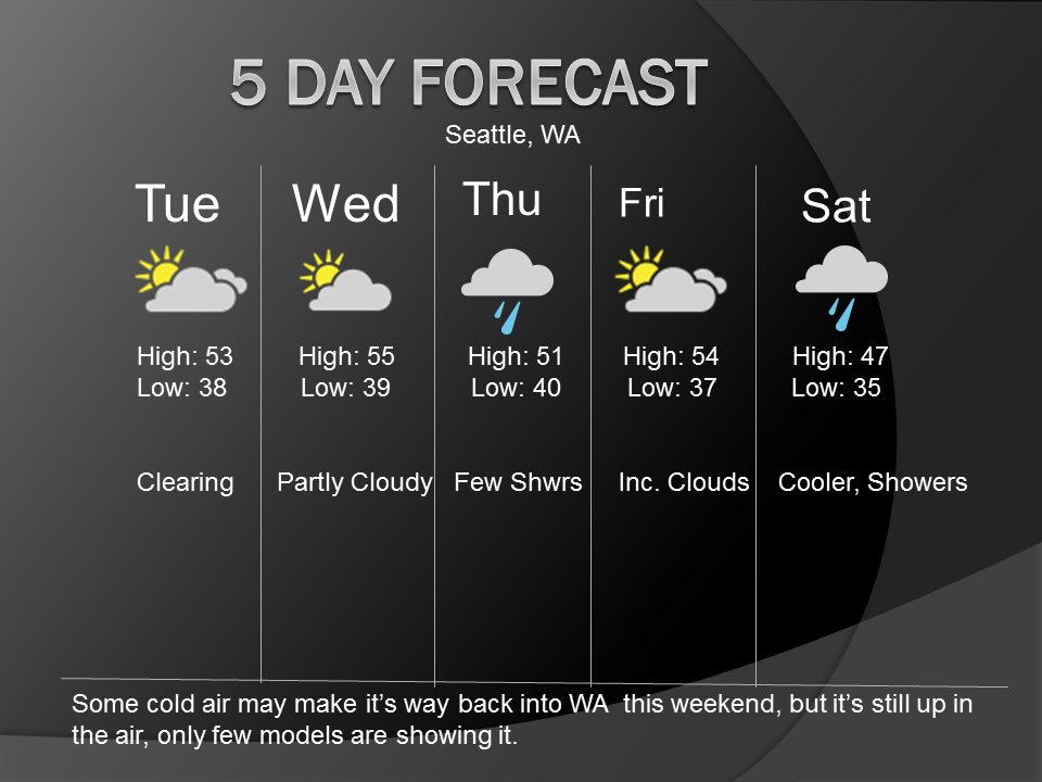
Friday looks pleasent with a slight chance of a shower throughout the day, other than that, Partly Sunny with highs in the low 50s.

Saturday is the day the cooler air will be flowing in, as it is scheduled to start flowing into the region late Friday night into Saturday morning. Temps on Saturday should range from the upper 30s north to the low 40s in Seattle. Temps will warm the more South you go.

Precipitation on Saturday will be limited, but few models show some precip in the area on Saturday, there could be a rain/snow mix from Everett, north during the day Saturday. We could see the rain snow line drop more south then expected, so stay tuned for that.

Sunday looks more interesting, as a warm front will clash with the cool air, but it looks like a mainly rain event from Everett southward, but remember, don't rule out the chance that temps can be colder then expected, so the Everett south could change to Lynnwood south or even Seattle south. It could also go more north, so Everett South could change to Mt. Vernon south in terms of rain.

Snow amounts on Sunday looks like a good 1-4 inches north of the rain/snow line, amounts due to change.

Next week we look to rebound with mild temps in the low to mid 50s, it looks like a wet week also with some rain on Monday and Tuesday.

Super Long Range models don't show much in terms of interesting, just low 50s with showers next week.

Stay with us to monitor the snow situation this weekend.

-Grady, Western Washington Weather Blog


Wednesday, February 26, 2014

Quiet Next Two Days. Snow Chance for Weekend

We have had a very nice last two days with temperatures reaching the upper 50s in spots with mostly sunny skies. Tomorrow we should see temps cool down a bit with a slight chance of a P.M. Shower, highs ranging from 47-53. Friday should be a clone of Thursday, with highs in the low 50s with a chance of a shower.

This weekend looks very interesting right now. Models show cold air spilling out of the Frasier River Valley Friday night into Saturday. We should see high temps on Saturday and Sunday in the mid to upper 30s. The big question is, will we see any moisture?

Right now that question is still very up in the air. Some model runs of the GFS and the EURO show snow, while some runs don't show much moisture. As of Wednesday night, I would say a chance of snow for Western Washington for part of Saturday, and Sunday into Monday. Amounts are not in question right now, as we are still too far out.

Next week we look to bring back a mild and showery pattern, low to mid 50s for highs

I will continue to monitor this situation for the weekend, check back nightly for updates.

Grady. Western Washington Weather Blog

Tuesday, February 25, 2014

Mild tomorrow. Chilly Weekend

We actually received some sun today in most of the Puget Sound, with mild temperatures. Temps rose into the low to mid 50s in the afternoon, making it a great late winter day. Can we keep it going?

Tomorrow we should see even warmer temps, with mainly sunny skies, with a chance of increasing clouds later in the day, with high temps in the mid to upper 50s, maybe even reaching 60s in some spots. Mainly South if you want to feel that.

On Thursday we could see a slight chance of P.M. showers, mainly south. High temps on Thursday should range from 48 to 53. Friday looks almost similar, with highs getting in the low 50s with a chance of a shower, yesterday it looked like Friday would be warm and into the mid 50s again, but not anymore.

This weekend still looks like it's going to get cooler, but how cooler is the question. Some models show high temps getting into the upper 30s in some areas starting Saturday, with cold air staying over the weekend. The GFS model is the main model that shows this feature as of 9:00 P.M.Wednesday.

Snow? Doesn't look too likely right now, but we will see how this pattern develops. The model that showed a lot of snow for the Puget Sound last week, the UW-WRF model, shows about 6 inches in the Sound and 2 and a half FEET on the coast early next week, I will assure you there is a 99.9% chance that we will not see that much snow fall if we do get snow.

We will keep you updated on this situation during the coming days.

- Grady, Western Washington Weather Blog

Monday, February 24, 2014

Dry Streak Ahead This Week. Mild Too

Is anyone else tired of the rain, when before they were tired of it being too dry with no exciting storms? I am!

Is anyone else tired of the news covering the snow in Bellingham? I am!

In the North Interior this weekend and today, we saw A LOT of snow, as me being from Snohomish, we were supposed to get 3-6 inches and got nothing, so I don't want to talk about snow. Last time, Bellingham northward has a chance to get an additional 1-3 inches of snow, or maybe just FREEZING RAIN, so have another fun snow day kids, well, that's what it looks like is going to happen.

This week is basically supposed to be the same for all of Western WA this week, besides tomorrow morning when Bellingham northward has to deal with some freezing rain and snow still around, this area should get into the mid 40s tomorrow. Snow should start to melt. We also may still see a few showers around the Sound tomorrow morning as well, nothing big though.

Tomorrow, should see temps rise into the low to mid 50s, besides the mentioned above Northern Interior with slightly cooler temps in the mid 40s. Wednesday looks warmer and dryer with temps ranging from about 50 to 57, and partly sunny skies, a beautiful February day.

Thursday afternoon we may see a little disturbance reach the area for a few P.M. showers, with highs ranging from 48 to 52.

On Friday, we look to have basically a clone of Wednesday, with Partly Sunny skies with temperatures ranging from 50 to 55, another nice February day, a very nice break this week from all the rain we have had recently.

This weekend, models are very mixed, the most accurate of all the models, one of the runs of the EURO model shows cold air returning with a chance of precip, which may bring snow back to WA. Also one of the GFS model brings cold air in, with limited precip. Only two models show this, so I'm not putting anything in the forecast yet, just mid to upper 40s for the weekend with a chance of a shower on Saturday.

Long Range models show dry weather, with cool temps all the way into the middle of next week.

12-16 days from now still looks pretty warm and dry, with temps in the upper 50s and low 60s, models still most likely going to change though.

- Grady, Western WA Weather Blog


Sunday, February 23, 2014

Blog Change: Big Snow North; Mild Week Ahead

SW Snohomish County Weather is gone, I have now made this page all of Western Washington Weather, this post is right after the update at 11:30 P.M. Sunday Feb. 23rd 2014.

Quick Update: About Mt. Vernon north received a LOT of snow the last 24 hours, low totals amount to about 6-7 inches and highest totals ranging from a foot to a foot and a half in places.

Everywhere south of Mt. Vernon was basically left blank besides some wet snow Saturday morning for most folks, but nothing accumulated.

This was a major busted forecast for me, and the National Weather Service, predicting 3-6 inches of snow all the way south to about Lynnwood. That obviously didn't happen.

This week looks mild with temps in the low to mid 50s, with dry conditions Tuesday through Thursday evening, with some rain Thursday night. We should dry off for the weekend with temps in the low to mid 50s with a slight chance of a shower.

Super Long Range models show very warm temps in the low 60s about 12-16 days from now, something to keep an eye on.

- Grady, Western WA Weather Blog.

Thursday, February 20, 2014

This Weekend May be a Snowy One - Warmer Next Week

We have not had much snow at all this winter, besides the two events that brought us snow in the night/early morning hours in late December and two weeks ago, both events brought us a couple inches of snow.

This weekend is looking very exciting still, but it's still not for sure just yet. For the Northern counties it's almost a guarantee, but for Snohomish County, it's still very up in the air, but I am putting it in the forecast now. Some models are showing lots of snow, the American (GFS) model shows almost 8 INCHES of snow in the Southwest Snohomish County area, but the European model (ECMWF) is showing less. That is why the forecast is still up in the air for now, we should have more info tomorrow evening.

Friday looks much like Thursday, a few showers, but a bigger chance of a sun break than Thursday. Cold air from Canada will invade the area tomorrow night into Saturday morning, dropping temperatures into the upper 20s and low 30s during that time. One more confusing thing that's still up in the air about this event is how much cold air we will get in our area, we just don't know yet, but I'm putting upper 30s for highs on Saturday, and low to mid 30s for Sunday.

Now that we went over the weekend event, let's talk about next week. Monday looks warmer and dryer as we start the new week, with highs in the mid to upper 40s, and partly cloudy skies, any snow that fell during Saturday and Sunday should melt Monday. Tuesday highs will bump into the upper 40s with more partly cloudy skies. Wednesday still looks warmer and dry, with highs in the low to mid 50s.

Beyond Wednesday looks to stay at about 50 degrees with showers Thursday and Friday.

I will most likely issue a Winter Storm Watch tomorrow night if models continue to show snow. As a snow fan, I hope this happens, hopefully even get a snow day on Monday, if this happens.

Thanks for reading :)
- Southwest Snohomish County Weather Blog


Wednesday, February 19, 2014

First Post: Extended Forecast Confusion for the Weekend.

I'm just going to keep this plain and simple, the forecast for the next two days is rather boring, just a chance of showers Thursday and Friday, but there is a possibility of some rain/snow Thursday night in the PSCZ (Puget Sound Convergence Zone) in North King and South Snohomish counties, I don't expect much accumulation if this occurs, maybe a dusting to a half inch, not likely though. Friday is much like Thursday, but without A.M. rain, just a chance of showers throughout the day, highs in the mid 40s. During the weekend is when things start to get tricky. There will be some showers throughout the day on Saturday, with a chance of some SNOW to the north, especially Snohomish County northward, I wouldn't get too excited yet, but it's something to keep an eye on. Other than that, highs in the upper 30s to low 40s is my best bet for Saturday, with a chance of a rain/snow shower. On Sunday, it looks really tricky, a front as of now (2/19/14) is expected to reach the Northern half of Western WA on Sunday (Snohomish County North.) It looks like this front will bring snow to the northern part of Western WA as of 2/19/14. If these model runs continue to show these features, I will change the five day, but for now, I'll leave it with upper 30s to low 40s with a chance of a rain or snow shower. Monday looks like it's going to warm up back into the mid 40s, with partial clearing during the day. Tuesday onward looks pretty good for dry and sun lovers as some models show Partly Cloudy skies with highs in the LOW to MID 50s. We will have to wait and see if models continue to show that, but for now, that's what it looks like.
Thanks for reading my first blog! I'm a 14 year old weather lover, so my writing might not be amazing, but I still enjoy doing this!
- Western Washington Weather Blog
:)